Largest State in India 2021: Check the list of all states by area and population
In terms of area, India is the seventh-largest country in the world (3.287 million km²) and is the second-most populous country in the world after China.

At present, India has a total of 28 States and 8 Union Territories. In terms of area, it is the seventh-largest country in the world (3.287 million km²) and is the second-most populous country in the world after China. India is home to 17.5% population of the world and occupies 2.4% of the world's area. This article will provide you with a list of all the States and Union Territories by area and population.
Highlights:
1- Rajasthan is the largest Indian state by area followed by Madhya Pradesh and Maharashtra while Goa is the smallest Indian state.
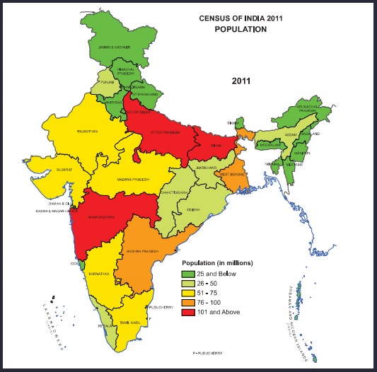
2- Uttar Pradesh is the most populous Indian state followed by Maharashtra and Bihar while Sikkim is the least populous state in India in terms of area.
3- Ladakh is the largest Union Territory of India by area followed by Jammu and Kashmir and Andaman and the Nicobar Islands while Lakshadweep is the smallest Union Territory of India in terms of area.
4- NCT of Delhi is the most populous Union Territory of India followed by Jammu and Kashmir and Puducherry while Lakshadweep is the least populous Union Territory of India.
List of States & UTs by Area and Population
| S.No. | States | Region | Area (in Km2) | Population |
| 1. | Andhra Pradesh | Southern | 160,205 | 49,577,103 |
| 2. | Assam | Northeastern | 78,438 | 31,205,576 |
| 3. | Arunachal Pradesh | Northeastern | 83,743 | 1,383,727 |
| 4. | Bihar | Eastern | 94,163 | 104,099,452 |
| 5. | Chhattisgarh | Central | 135,191 | 25,545,198 |
| 6. | Goa | Western | 3,702 | 1,458,545 |
| 7. | Gujarat | Western | 196,024 | 60,439,692 |
| 8. | Haryana | Northern | 44,212 | 25,351,462 |
| 9. | Himachal Pradesh | Northern | 55,673 | 6,864,602 |
| 10. | Jharkhand | Eastern | 79,714 | 32,988,134 |
| 11. | Karnataka | Southern | 191,791 | 61,095,297 |
| 12. | Kerala | Southern | 38,863 | 33,406,061 |
| 13. | Madhya Pradesh | Central | 308,252 | 72,626,809 |
| 14. | Maharashtra | Western | 307,713 | 112,374,333 |
| 15. | Manipur | Northeastern | 22,327 | 2,570,390 |
| 16. | Meghalaya | Northeastern | 22,429 | 2,966,889 |
| 17. | Mizoram | Northeastern | 21,081 | 1,097,206 |
| 18. | Nagaland | Northeastern | 16,579 | 1,978,502 |
| 19. | Odisha | Eastern | 155,707 | 41,974,219 |
| 20. | Punjab | Northern | 50,362 | 27,743,338 |
| 21. | Rajasthan | Northern | 342,239 | 68,548,437 |
| 22. | Sikkim | Northeastern | 7,096 | 610,577 |
| 23. | Tamil Nadu | Southern | 130,058 | 72,147,030 |
| 24. | Telangana | Southern | 112,077 | 35,003,674 |
| 25. | Tripura | Northeastern | 10,486 | 3,673,917 |
| 26. | Uttarakhand | Northern | 53,483 | 10,086,292 |
| 27. | Uttar Pradesh | Northern | 240,928 | 199,812,341 |
| 28. | West Bengal | Eastern | 88,752 | 91,276,115 |
| S.No. | Union Territories | Region | Area (in Km2) | Population (in) |
| 1. | Andaman and Nicobar Islands | Bay of Bengal | 8,249 | 380,581 |
| 2. | Chandigarh | Northern | 114 | 1,055,450 |
| 3. | Dadra and Nagar Haveli and Daman and Diu | Western | 603 | 585,764 |
| 4. | National Capital Territory of Delhi | Northern | 1,483 | 16,787,941 |
| 5. | Jammu and Kashmir | Northern | 42,241 | 12,267,032 |
| 6. | Lakshadweep | Arabian Sea | 32 | 64,473 |
| 7. | Ladakh | Northern | 59,146 | 274,000 |
| 8. | Puducherry | Southern | 479 | 1,247,953 |
Note: The above data is from Census 2011 as published by the Office of the Registrar General & Census Commissioner, India. The data will be updated as and when the next census will be held in the country.
Do You Know? The first population census in British India was conducted in the year 1872. Independent India's first census was conducted in the year 1951 and has since then been conducted every 10 years. The Office of the Registrar General and Census Commissioner under the aegis of the Ministry of Home Affairs (MHA) conducts the census in India. |

Comments
Post a Comment